
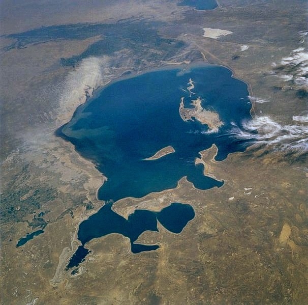
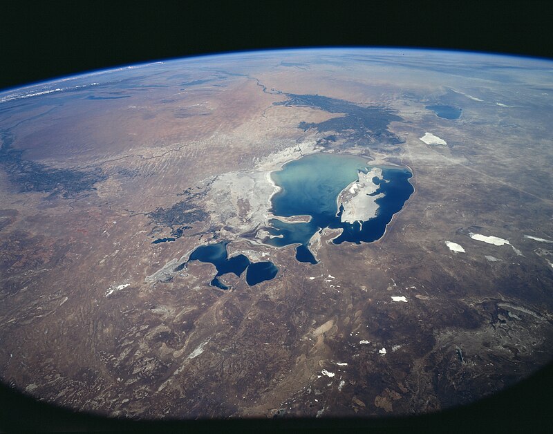
The Aral Sea was an endorheic lake lying between Kazakhstan in the north and Uzbekistan in the south. Formerly the fourth largest lake in the world with an area of 68,000 km2, the Aral Sea has been shrinking since the 1960s after the rivers that fed it were diverted by Soviet irrigation projects. By 1997 it had declined to 10% of its original size splitting into four lakes. By 2009 the southeastern lake had disappeared and the south western lake had retreated to a thin strip at the western edge of the former southern sea. Satellite images take by NASA in August 2014 revealed that for the first time in modern history the eastern basin of the Aral Sea had completely dried up. The eastern basin is now called the Aralkum Desert. The shrinking of the Aral Sea has been called “one of the planet’s worst environmental disasters”.
In the early 1960s, the soviet government decided the two rivers that fed the Aral Sea, the Amu Darya in the south and the Syr Darya in the east, would be diverted to irrigate the desert, in an attempt to grow rice, melons, cereals and cotton. This was part of the Soviet plan for cotton to become a major export. This temporarily succeeded and in 1988 Uzbekistan was the world’s largest exporter of cotton.
The construction of irrigation canals began on large scale in the 1940’s. Many of the canals were poorly built, allowing water to leak or evaporate. From the Qaraqum canal the largest in Central Asia, nearly 30 to 75% of the water went to waste. By 1960, between 20 to 60 km3 of water each year was going to the land instead of the sea. Most of the sea’s water supply had been diverted and in the 1960’s the Aral Sea began to shrink. From 1961 to 1970 the Aral’s level fell at an average of 20 cm in a year and by the it continued to drop now with a mean of 80-90 cm each year. The disappearance of the lake was no surprise to the Soviets and a Soviet engineer in 1968 said, “it is obvious to everyone that the evaporation of the Aral Sea is inevitable.”


Possible Environmental Solutions
Improving the quality of irrigation canals
Using alternative cotton species that require less water
Promoting non-agricultural economic development in upstream countries
Using fewer chemicals on the cotton
Cultivating crops other than cotton
Redirecting water from the Volga, Ob and Irtysh rivers to restore the Aral Sea to its former size
Pumping sea water into the Aral Sea from the Caspian Sea using a pipeline.
Aral Sea Basin program
In January 1994, Kazakhstan, Uzbekistan, Turkmenistan, Tajikistan and Kyrgyzstan signed a deal to pledge 1% of their budgets to help the sea recovery.
The future of the Aral Sea and the responsibility for its survival are now in the hands of the five countries: Kazakhstan, Uzbekistan, Tajikistan, Kyrgyzstan and Turkmenistan. In 1994, they adopted the Aral Sea Basin program.
The program’s four objectives are:
To stabilize the environment of the Aral Sea Basin.
To rehabilitate the disaster area around the sea.
To improve the management of the international waters of the Aral Sea Basin.
To build the capacity of institutions at the regional and national level to advance the program’s aims.
Future of South Aral Sea
The South Aral Sea, half of which lies in Uzbekistan was largely abandoned to its fate. Only excess water from the North Aral Sea is now periodically allowed to flow into the largely dried-up South Aral Sea through a sluice in the dyke. Discussions had been held on recreating a channel between the somewhat improved North and the desiccated South, along with uncertain wetland restoration plans throughout the region, but political will is lacking. Uzbekistan shows no interest in abandoning the Amu Darya river as an abundant source of cotton irrigation and instead is moving towards oil exploration in the drying South Aral seabed.
Attempts to mitigate the effects of desertification include planting vegetation in the newly exposed seabed; however, intermittent flooding of the eastern basin is likely to prove problematic for any development. Redirecting what little flow there is from the Amu Darya to the western basin may salvage fisheries there while relieving the flooding of the eastern basin.
References
https://en.wikipedia.org/wiki/Aral_Sea